Are you looking to break in your new hiking boots, start working on a hiking patch, or just want to get outside and enjoy all the beauty the Lakes Region in New Hampshire has to offer? The Belknap Range offers all this and more. The Belknap Mountain Range includes twelve prominent peaks located in the towns of Gilford, Gilmanton and Alton NH. Mount Major is by far the most popular hike in the Belknaps and offers stunning views of Lake Winnipesaukee. The parking lot is often overflowing with cars so getting there early is a priority! If you are looking to get off the beaten path, exploring the 11 other peaks in the Belknap Range is a must. The Belknap Range Trail Tenders (BRATTS) do an excellent job of maintaining the trails in the Belknap region.. The trails are well-marked and trailheads easily accessible. The “unofficial” Belknap Range Patch can be obtained by hiking each summit individually, as a full day traverse hitting all twelve peaks, or “peak-bagging” summits over several hiking excursions. If you have a trusty four-legged friend that joins you on your outdoor adventures, you can purchase a patch for them as well! If you are looking for a challenge, BRATTS offers a Belknap Range Redlining patch. “Redlining” the Belknaps requires you hike all sanctioned trails around the range which is over 65.5 miles of trails!
View from Mount Major on a crisp winter day
MOUNTAINS IN THE BELKNAP RANGE
- Belknap Mountain: 2382 feet
- Gunstock Mountain: 2245 feet
- Piper Mountain (North): 2044 feet
- Mount Klem: 2001 feet
- Mount Mack: 1945 feet
- West Quarry: 1894 feet
- Straightback Mountain: 1890 feet
- Mount Rand: 1883 feet
- Mount Major: 1786 feet
- Mount Rowe: 1680 feet
- Mount Anna: 1670 feet
- Whiteface Mountain: 1664 feet
TRAILS IN THE BELKNAP RANGE
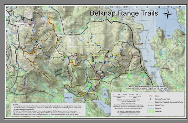
Trail system in the Belknaps
An excellent map of all current trails in the Belknap Range is offered in downloadable fashion through belknaprangetrails.org.
If you wish to purchase a current paper map, libraries in Gilford, Gilmanton, Laconia, Barnstead, Meredith, Center Tuftonboro and Sanbornton have maps available to purchase.
RESOURCES
Southern New Hampshire Trail Guide: AMC guide that offers descriptions of many trails in the Belknap Range as well as a map
belknaprangetrails.org: offers history of the Belknap range, trails and features in the Belknap Mountains, and a downloadable map
franklinsites.com: offers hiking list and links to photos and trail descriptions to each of the 12 peaks in the Belknap Range
newenglandtrailconditions.com : current hiking conditions in the Belknaps
belknaprange.org : offers maps, history and information about the Belknap Range Conservation Committee (BRCC)
4000footers.com : offers a printable list of the 12 Belknap Range Mountains as well as a link and directions to apply for the hiker achievement patch
BRATTS.org : Belknap Range Trail Tenders are a group of volunteers that maintain trails in the Belknap Range; the site offers information and links to volunteer for work days, adopt-a-trail, redlining and resources for hiking
Sadie enjoying the view from summit of Straightback Mountain
BELKNAP RANGE SERIES
This article is the first in a series of articles highlighting hiking and enjoying the four-seasons of beauty offered in the Belknap Range. Let us know if you have explored any of these peaks in the Belknap Range!
Last modified: November 21, 2017

Have hiked the Belknaps many times as we only live 7 min from the Scout Reservation. With the arrival of the pandemic, we set the goal to redline the Belknaps in 2020. Only have a few hikes left, as we are waiting for Mt Major to decrease in traffic. It has been wonderful fulfilling this goal. Love the Belknaps!