Carter Dome (4832′) lies on the eastern edge of the White Mountains immediately east of the Presidentials. It’s in good company near Middle and South Carter as well as Wildcat Mountain.
The forecast called for rain all day and thunderstorms. I had a feeling the weather would change for the better and decided I would still hike. Saturday morning I looked at the hourly forecast and there was no rain in sight!
The hike ended up being easier than I anticipated. The only tricky parts were the stream crossings as the water was so high. I only dunked one foot in once. I call that a successful hike!
| Half a bridge… |
| Brenda and Pete carefully making their way across |
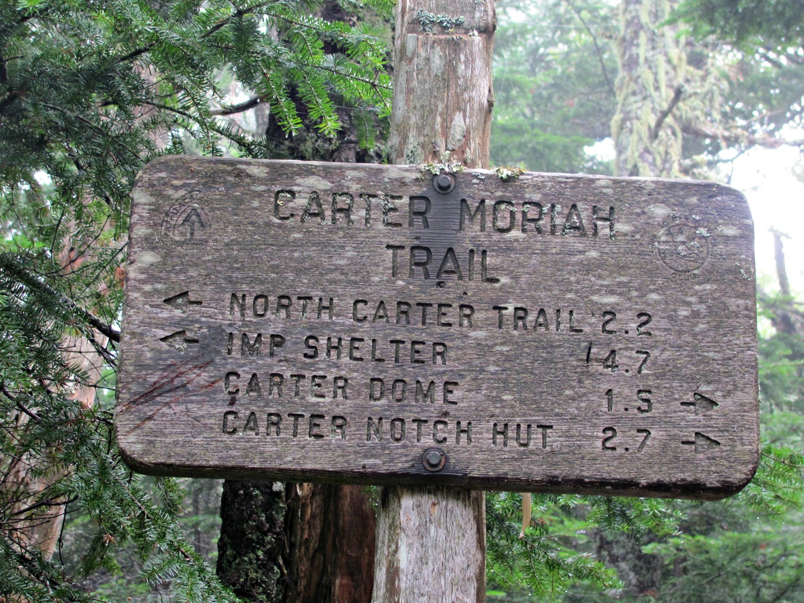
A little after this sign you have the option of climbing up to Mount Hight which is not a 4000-footer, but is supposed to have really nice views. We weren’t going to see any great views as it was so foggy so we went straight to Carter Dome.
There are some steep sections to the trail, but nothing really crazy like you see on a lot of the mountains in the Whites. There are some nice flatter sections as well to give your legs a break.
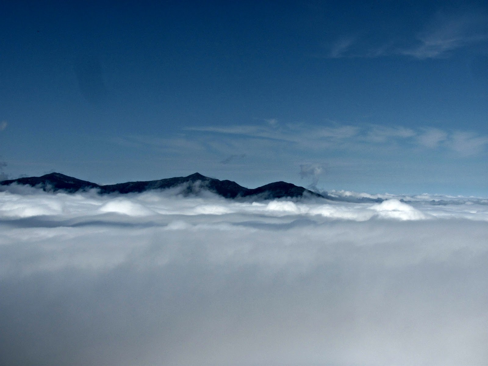
I had read about some “beautiful vistas” from this viewpoint, but all we saw was fog. We were very surprised by what we would see next…
The undercast we saw on Carter Dome was by far the most beautiful I have ever seen. The clouds were so thick it looked like you could walk right across to the Presidentials.
One of my hiking friends, Anne didn’t join us because of the weather reports. I did her signature pose atop Carter Dome as we were thinking about her!
We spent quite some time on the summit eating lunch, chatting, and chasing butterflies.
We did a loop on this hike. If you look on a map it looks like a tulip! A couple we met as we were descending told us the trail gets much steeper. This is where we knew they weren’t kidding! I’m glad we didn’t come up this way!
Wildcat Mountain hiding in the fog. If you plan on doing Carter Dome, Wildcat A is only .7 miles away!
| Looking back at Cater Dome |
We made a wrong turn and ended up at the hut, whoops! It smelled like brownies. We just had to turn back to the pond and continue on the Nineteen-Mile Brook trail.
We passed a boy carrying up supplies to the hut. It was pretty humid out and he was going up quick! Not a job I’d like to have!
Quick Facts:
Approach from: Nineteen-Mile Brook Trailhead
Height: 4832′
Distance: 10.2 miles RT
Elevation Gain: 3750′
Time: 6:40 book time
Directions to trailhead:
Nineteen-Mile Brook Trail is located 1 mile North of Mt. Washington Auto Road on the East side of Rt 16.
Last modified: July 13, 2017
Looks like an awesome hike, Allison. The crossings on 19-mile Brook Trail look a lot higher than when I hiked that trail last couple of times. Magnificent undercast!
No matter the weather, I always say go hiking. You never know what surprises you will find (such as the unexpected sunshine and clouds on top!) Looks like a you had a great time. Thanks for sharing.
Man, those undercast photos are beautiful!