Gripping a root on the edge of a mountain was not something I imagined doing when I read the trail description in Appalachian Mountain Club’s White Mountain Guide. I pull myself up the steep grade as rocks tumble down below me. Upper body strength is something I lack. I sit on the ledge I just ascended and pull out my map. It’s practically useless as I have no idea where I am. I decide to continue going up.
I find a route that’s not nearly as steep, but thick. I force my way through an obstacle of pine trees, roots, and never ending undergrowth. I am repeatedly stung by branches whipping back at me. I take a break from staring at my feet and look toward the sky. I must be getting close. Grace isn’t a word to describe my ascent. I am constantly stepping over down trees, getting jerked back by branches catching on my pack, and ducking under thick branches at the perfect height to walk straight into. I trudge.
I grab a root and pull myself up, my feet sliding backwards on the wet soil. I am almost there. I take a deep breath and lunge up, reaching for a close branch. I finally see a flat surface. It looks like somewhere a hiker is meant to be. Thankfully I am the only one here and have time to look over my map. All of that effort led me to the tiny, viewless summit of East Osceola. I didn’t know it for sure at the time, though. A couple comes into sight and asks me if this is the top. I respond confidently that it is.
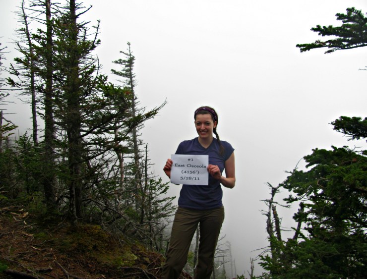
Would you guess I had bushwhacked East Osceola? Still proud of peak #1
Bushwhacking up 4,156 foot East Osceola is not how I imagined my first solo hike to go. I take a breath and begin up the trail toward Osceola’s main peak. It is smooth sailing until the chimney section. This is what I had been warned about. While the Osceolas are a tame duo, the chimney can get to some hikers. I grasp a section of rock and pull myself up. I appreciate the stable hand and footholds. The trail post chimney is wonderfully easy to follow and soon enough I find myself on a large rock slab. While Mount Osceola is known to have superb views, I only see white. The summit is surrounded by a thick fog. I’ve made it to summit number two.
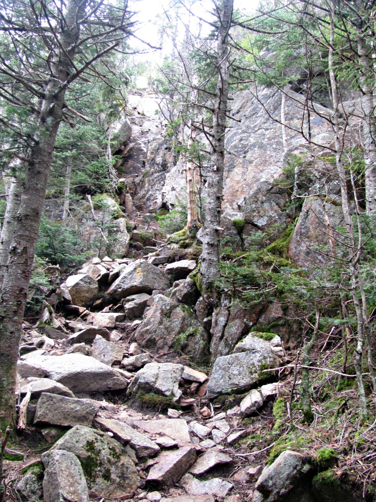
Approaching the chimney
As I descend, I try and figure out where I went wrong on my way up East Osceola. It turns out I continued on one of the Greeley Pond ski trails. And this is how I began my NH 4000 Footers. Three rounds later, I’ve grown a lot as a hiker. Do I still get lost? Occasionally. Does it ever become easy? Hell no.
So why am I sharing this story now? I’ve been open about my adventures, both successes and failures. If you’re starting your own journey, know that it’s not always straightforward. There will be times that you make horrible decisions or may be unprepared. You will feel weak. You may have to turn back for a variety of reasons. You may not feel like you belong out there.
I continued to solo hike, originally with the intent of proving everyone wrong about a story I had never told. I poured over maps, joined hiking forums, and read every trip report about the trails I intended to hike next. I vowed that I would share all my adventures, both successful and not. These attempts or mishaps not only shape me as a hiker, but also serve as an important lesson for others.
Take time to reflect on your journey, especially when it doesn’t go right. I challenge you to share your own hiking mishap. After all, if it were easy everyone would be doing it.
Be brave. Share a hiking failure in the comments below.
Last modified: September 2, 2017

When we decided to hike Owl’s Head, we opted for the bushwack from Black Pond. Our son bought my husband a new compass for us to use, we thought this was gonna be great, a little shortcut through the woods, but needless to say, we got lost. Had we taken out our map and checked it out, when the Bonds were to our right we would have known we ended up on the wrong side of owls head slide., Thank God there were people sitting at the base of the slide and told us that was the way up/ We were looking to the wrong side of the trail for the way up and never would have seen it. So we learned to always check the map even if you know you are right. Just in case! Happy Trails to you too 🙂
Hiking up the Yosemite Falls trail in January. This was my first winter trip and my first time on that trail. There were many firsts, but you have to start somewhere.
I was running late and started out at far to fast a pace. It was my first time with a lighter pack and I felt strong. I know better, but the excitement and urgency to get going blinded me to my error. I realized I was going way to fast part way up. However, the damage was done. The nearer to the top I got the more worn out I became. At one point I was walking, slowly walking, for 30 seconds and then stopping for 30 seconds. I was exhausted. Because of the late start I made the top in the dark. I was tired and hungry, but wanted to make camp before stopping for dinner. I wanted to reward myself with a nice “sit down” dinner and wine (I brought wine). I turned on my headlamp, but had it in low/flood mode and lost the trail. I checked the GPS on my phone often enough to almost kill the battery trying to find the trail. I knew I had to be crossing it but could not see it well enough with the limited light from my headlamp to recognize it as a trail. I finally gave up trying to find my planned campsite and made camp once I knew where the stream was (I was almost out of water too by this point).
When I was hiking back out two days later, in the daylight, I tried to see where I lost the trail. I had assumed it would not be well defined for a short distance and that would be where I lost it. Nope, couldn’t figure out how I couldn’t see it. The combination of fatigue, hunger and impatience did me in.
I did have a great trip and learned a lot. There has to be a first time.
Hi Allison…I am Howard, and my first big mistake or lack of judgement came when I was doing my 48. It was 11-18-12. I parked at the Tramway parking lot for Mt. Cannon. I decided to do a loop, which consisted of The Pemi Trail, to Lonesome Lake Trail, to Hi Cannon Trail to the Summit. I was alone and had micro spikes. I made it to the Summit with no problem…I am very fit, and had no fear. But I was about to be humbled. After taking in the views from the Observation Tower/Deck, I started my descent…using the Rim Trail to Kinsman Ridge Trail to the Tramway Parking Area. Well as soon as I hit the the steep section of Kinsman Ridge Trail, there was ice….lots of ice, and very thick. My Micro Spikes were not gripping very well, and I was slipping and falling, having to slide on my butt, and grab onto trees so I would not slide off the trail.I did not have Crampons, nor did I know how to use them…that would change later, and is another story. As I continued my descent, it was becoming more harrowing. Lucky for me, there were ropes between trees, that I guess is part of some ski trails, and that helped me through that section. But I was very frightend, and ALONE!!! This would be my next to last solo hike, it should have been my last. I finally managed to make it to an easier grade on the trail, and was relieved, and grateful. As I continued toward my car, I came upon an elderly couple going up. They told me to watch out for ice, and asked if it was worse up top. They also only has spikes, and I told them my experience, and they decided to turn back, as did a Mon and her 4 year old daughter, trying to do her 4th 4k footer, Asolo’s and all. I learned that day, that hiking in Winter like conditions was a different animal, and I needed lots of training. That’s when I found Meetup Groups and met many experienced hikers, who I constantly asked questions about everything to do with hiking in the Whites. Today I am 9 Peaks away from finishing my NE 67. It took me 8 months to do the 48. I have learned so much about myself, and this wonderful thing called hiking. Thank You God, for allowing me to share and enjoy your beautiful world. The End….by. HSA
I’ve hiked the Northeast 111, so I think it’s safe to say I’m an experienced hiker. Nonetheless, when I hiked Snow Chain-of-Ponds in Maine a couple months ago I made a wrong turn driving to the trailhead, I made a wrong turn going up the mountain, and I made a wrong turn coming down the mountain. I ended up bushwhacking most of the way up, even though it’s a trailed peak. It was the second hardest bushwhack of my life. On the way down I went on the trails, but still managed to make a wrong turn I had to backtrack from.
A friend and I early in October got a late start to hike the Bigelow Range, first to Avery Peak and then over to the Horns and back to the starting point. As we descended into the camping area I was certain where the trail left the AT that we wanted to take. It went by the outhouse and soon the blazes became faint and the trail less well defined. My friend kept asking me if we were on the right trail. I said of course we were as the sun started to go down and we began to climb over and around major blow downs. Soon we lost sight of the remnants of old blazes and entered raspberry patches and blow downs. By then I had to admit it was not the trail. Luckily the moon was full and sky was clear. And when lost we walk downhill to water and then follow the stream downhill. So downhill we went for say 30 minutes. We finally heard a stream and headed toward it when we popped onto the real trail. We had been on the very old AT that had been relocated many years earlier after a big blow down. Needless to say we made it out under the cover of moon light. And I bought the beer and dinner that night.
My daughter and I planned to do Little Haystack, Lincoln and Lafayette going up Falling Waters, over the ridge and down to Greenleaf hut and the Old Bridle Path. Cloudy day in late September, beautiful none the less. Above the tree line, weather closed in, rain, 40 mph winds and in the clouds. Never saw the sign and missed the left turn to Greenleaf and continued on the ridge toward Garfield. At the junction with the Skookumchuck Trail, I realized where I had gone wrong but also knew we were very cold and wet. We headed for the tree line. I knew we would come out a distance from the car but wasn’t worried - Momma’s Got a Thumb - after all! As we approached Route 3, Tori looks at All Trails and it dawns on her - we are nearly 9 miles from the car! “Mom, there aren’t any Ubers out here!” I tell her we are going to hitch a ride as I calmly stuck out my thumb with my pack at my feet. Mortified that Mom is actually hitching, she stands behind the guardrail swearing that she won’t get into anyone’s truck! Third car stops, clears out the back seat and drives us to the trailhead. Trail Angels abound! I did leave my nearly new Hiker Hunger trekking poles leaning on a rock in the parking lot - I hope someone is putting them to good use - ask the poles to tell you the story of Mt. Adams - it’s a hoot and a half!