I hope this helps as a general guide for preparing for a JMT hike. I have included important links and resources that will be beneficial. Congratulations on deciding to take on this hike! You’re going to love it.
Yosemite wilderness permit reservations are available 26 weeks (182 days) in advance. Apply exactly 182 days in advance as permits go quick! You can find out what day to apply for your permit here.
If you reserve your permit ahead of time, you can do so beginning at 5 pm Pacific time a day prior to the date listed on the site’s timeline. If you fax your request by 7:30 am on the day listed, your request will be included in the daily lottery.
For weekend reservation dates, you can fax beginning 5 pm on Friday. If you missed the first day to make a permit reservation, you can see which trailheads are full here. Applying for a permit costs $5.00
You can request a permit using the following methods:
(The National Park Service’s preferred method is fax)
Standard faxing- The permit office fax number is: 209-372-0739
Send a fax online! I used Hello Fax to send mine. It’s free!
Phone- I know a handful of people who requested a permit over the phone. Still fill out a permit application to have pertinant information ready when you call.
The permit office number is: 209-372-0740.
The phone is staffed Monday through Friday, 8:30 am to 4:30 pm with extended hours from Memorial Day through Labor Day (Monday through Friday, 8 am to 5 pm, and Saturday, 9 am to 4 pm). Notice the hours for calling in are after the accepted fax times. Fax requests are processed before phone calls, but if you have any permit issues, calling could be a solution.
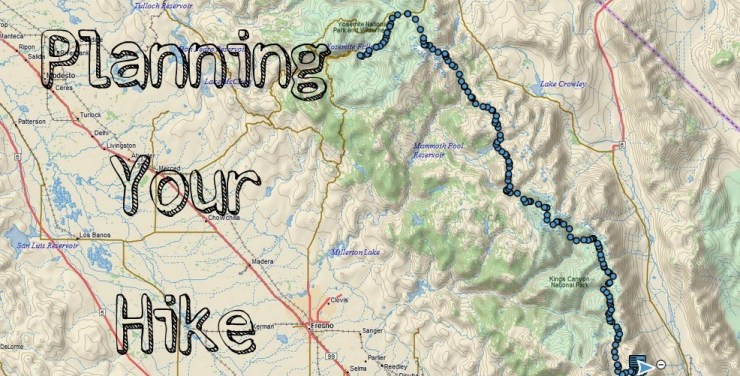
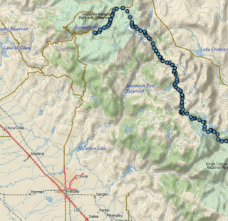
The official northern terminus of the JMT is at the Happy Isles trailhead in Yosemite Valley. However, John Muir did not walk this “official” route as the trail was completed 47 years after Muir’s death. There are many viable options to hike this trail.
*Yosemite National Park now limits reservations who intend to hike the JMT via the historical route of exiting Yosemite NP at Donahue Pass to 35 reservations a day and for walk-in permits, limit them to only those who apply to start their walk-in permit at Tuolumne Meadows.
This Exit Quota is limited only to Donahue Pass, not to the other passes on Yosemite’s southern borders (such as Fernandez Pass, Isberg Pass, Mono Pass, Parker Pass).
For more information on the new permit rules, please view this thread
If you are a member of the JMT Yahoo group, you can see additional information on trailhead options here.
How are you going to get to the trailhead? If you need to fly in, consider the following airports:
Reno, Nevada is one of the easier airports to access the JMT from, especially flying round trip but into Yosemite and ending in Lone Pine. To get into Yosemite Valley (for the most common start at Happy Isles) you will take the Eastern Sierra Transit to Lee Vining where you can transfer to YARTS for your connection to the northern terminus of the JMT. The Eastern Sierra Transit and YARTS schedules do not line up very well so you should plan to spend a night in Lee Vining.
As of 9/25/14 it will cost $37.00 for a ride on the Eastern Sierra Transit from Reno to Lee Vining and $13.00 from Lee Vining to Yosemite Valley
From Lone Pine you can take the Eastern Sierra Transit to the Reno airport.
San Francisco, Sacramento, Oakland, Fresno, Los Angeles, and Las Vegas all provide reasonable access to the John Muir Trail as well. From California, you will take a taxi to Amtrak to YARTS (in Merced) or a taxi to Greyhound or Amtrak and then on to connect with Eastern Sierra Transit (in Reno). *I spent some time in California before my hike and flew into San Francisco and out of LAX.
Flying into the Mammoth Lakes airport and then hiring a private shuttle or connecting to Eastern Sierra Transit is another option but it may be much more costly.
The Yosemite Valley Shuttle service within the park is free. There is a fee for each car within the park. You can access multiple trails for day hikes, the Valley grocery and gift store, a visitor center where you can pick up your permits, and the Happy Isles Trailhead (stop 16).
There are many wonderful resources available to assist you in planning your thru hike. Books, maps, forums, and blogs were resources I used in planning my JMT hike.
Books:
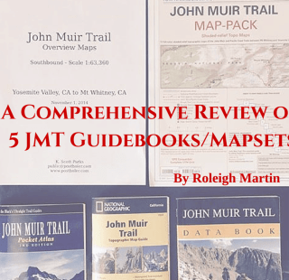
Elizabeth Wenk’s guide book is a must have and it was just updated in 2014! There is also a data book if you would like that doesn’t have all the not as neccessary (but still interesting!) information about the flora and fauna on the trail. Both are available as paperback or kindle versions.
Ray Rippel has an e-book that is very useful and even provides a few itinerary examples. At only $7.00 it’s well worth getting. He also writes a blog on hiking the JMT.
Maps:
I used the Tom Harrison JMT TOPO Maps on my hike. It contains 13 detailed topographic maps for each section of the JMT. They are waterproof (I definitely tested that out!) and are easy to mark up with a permanent marker.
A lot of people also like Erik the Black’s JMT pocket atlas.
Though the JMT is generally very easy to follow, I highly recommend having paper maps. In addition, I used Guthook’s JMT Hiker App on my phone. I mainly used it to quickly figure out distances, especially to refer to when journaling at night. It is very easy to look up the elevation of any major point on the trail and learn a little history of the passes. This app does not require the internet on the trail. You can use it while your phone is in airplane mode to save battery life.
Forums:
There are multiple online resources to share ideas and ask questions from others planning a JMT hike and also folks who have already thru hiked the JMT. This is a great resource to bounce ideas off people in the same situation as you or have experience doing what you plan to do. It is not a place to ask basic questions that you can easily research via a guide book or map.
John Muir Trail Yahoo Group: Very active group with many people who have thru hiked the JMT multiple times. You can get a daily email in your inbox. There are also numerous resources available in this group such as the JMT Crib Sheet.
Facebook-
If you are looking for almost automatic feedback, check out one of following groups:
John Muir Trail
John Muir Trail Hikers 2014 (just do a search for your year on facebook)
Ladies of the JMT- This group is for women only and are strict on screening new member requests. Sorry guys, no “what bra should I get for my hike?” advice for you 😉
Whiteblaze is a great resource for the AT and while they do have a JMT forum, it’s not as popular as the options above.
Blogs:
In no particular order, the following blogs focus on hiking the JMT and are great resources:
SoCalHiker
A collection of trail journals can be read here
Girls on the Way Fellow New Englanders! A woman and her two young daughters thru hike the JMT.
Lady on a Rock (she was a NOBO hiker!)
If you missed out on my trail journal, you can read all about my hike here!
Once you have scoured the internet, memorized the route on your map (I kid!), and took in as much information as your brain can handle, it’s time to start planning! Here are some things to think about:
How many miles per day do I think I’ll be comfortable hiking?
What about my hiking partner(s)? if not hiking solo
What are the most difficult sections on the trail?
How many days do I have available to hike the JMT? Do not forget to include travel time and possibly a spare day or two in case you need it.
Do I handle altitude well? If not or you have no experience, I suggest starting with less mileage in the beginning to adjust better.
From this information, create an itinerary. You will most likely not follow it but it is good to have a general idea of your hike. Planning it out like this will at least make you more familiar with the elevation changes and difficult sections where you will need to do less and also the days you can bust out the miles. You will be able to decide if you want to take a zero day and possibly where as well.
It is reassuring for folks at home to know your general plan as well, but stress the fact that your plans may change (even on day 1 or 2!) If friends and family are concerned, consider getting a Spot Satellite GPS Messenger or Delorme InReach device.
The only way to really get in hiking shape is to hike! If you happen to live near the Sierras, you have a head start! If not, take advantage of what you have! I consistently hike in New Hampshire’s White Mountains and just called my hikes leading up to the JMT “training hikes”. I would seek out routes to do more mileage on rough terrain. New Hampshire (the granite state) has much rockier and steeper trails than the JMT so if I could do bigger mileage days out here, I’d do fine out West. I did hike Brokeoff Mountain ( Lassen Volcanic National Park) in California before I hiked the JMT to see how I’d do at altitude as well.
Try to find a challenge near you and take the gear that you’ll be carrying on the trail. Please do not fill your pack with rocks or other useless items. Practice packing what you plan on bringing and if you feel adventurous, pack your bear canister if you have one! I wanted to chuck my BV500 off a cliff, but by the time I started the JMT I was over how heavy and bulky it was.
If you don’t have access to mountains, become a gym rat, take the stairs, or walk to work. Just get moving! It’s very different to hike all day everyday and you need to take the time to prepare physically and mentally!
While you’re doing your training hikes you can also begin to think about the gear you’ll take on the JMT. Think about what you will definitely take, what you need to replace/upgrade, and what you don’t have. When you think your gear list is dialed in, go on an overnight or multi-day hike. When you return, make a pile of items you used, seldom used, didn’t use at all. Keep all necessary items like a first aid kit that may be in your “didn’t use” pile, but really consider everything else.
In order to go lighter, stay warmer, or hike more efficiently you most likely will be looking at your big three (shelter, sleep system, and pack) the most. Check out my post on the big three here.
Begin your search for new or updated gear early. Here are my favorite places to score deals on gear:
Sierra Trading Post: You can usually find a coupon for at least 25% off online.
Backcountry:
Really fast shipping and large inventory. They usually have some great deals on wool baselayers.
Gear Trade: Buy or sell outdoor gear
REI Outlet: Sometimes there are awesome deals on the outlet site of REI. If you are a member, there’s a 20% off coupon twice a year, including the outlet.
Anti Gravity Gear: Fast shipping and wonderful customer service.
Moosejaw: Have sales often. Carry many brands.
Trail and Era: Shop multiple ultralight cottage gear manufacturers in one place!
Gossamer Gear: I wore the Mariposa on my thru hike. Great packs and accessories as well.
The Clymb: A huge variety of discounted gear. You can get notifications via email.
Ebay: With some luck, you may score a Western Mountaineering Bag like I did 🙂
Facebook Hiking Gear Flea Market: Keep your eye out for great deals. You may find someone has what you’re looking for!
Amazon: If you have prime, nothing beats the free 2 day shipping. Huge inventory.
Steep and Cheap: I’ve never bought anything here, but a lot of hikers I know are big fans.

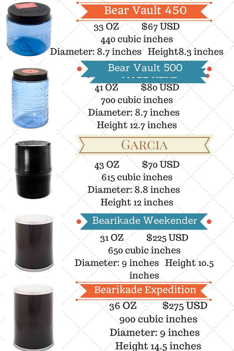
If you don’t already own a bear canister, you have a lot of options. You can purchase or rent a bear canister, but it must be approved for use within the national parks on the JMT. You can rent a Bearikade through Wild Idea’s site. Normally rentals are $5/day for the weekender and $6/day for the expedition. JMT hikers (along with a few other long distance trails) get a 45% discount on rentals.
The Garcia can be rented right in Yosemite. The cost is $5 per week with a $95 deposit (cash or credit card accepted, but you must pick up the cash deposit at the location where you rented the canister during business hours). Reservations are not available, nor are they necessary.
I wanted to do multiple training hikes carrying my canister and I hadn’t used on before so I wanted to have one well in advance to repackage and stuff my food in before sending out my resupply. I bought the BV500. I like that it’s clear so it is easy to see where my toothpaste or snacks are. I also like that it is completely waterproof. I hiked with a couple people who rented the Garcia and their canisters were much easier to open (need a quarter or something of similar size), but it is a big black hole for your food and not 100% waterproof. If you are hiking with someone else they can stack theirs upside down on top of yours to prevent any water from getting in.
The Bearikade expedition is very expensive, but a good choice for those wanting to rent, especially if you will be spending 8+ days after a resupply at Muir Trail Ranch. It is the largest and one of the lightest canisters available.
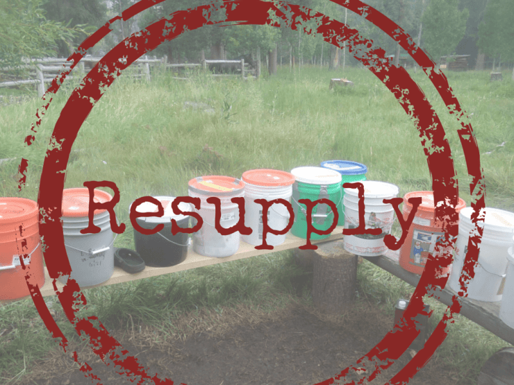
There are many resupply options hikers rely on to hike the John Muir Trail. All options below are on or very close to the John Muir Trail. Note that all distances are from Happy Isles. The last resupply option is Muir Trail ranch when hiking SOBO. Make sure to go to each resupply location’s website to follow ALL instructions to make sure you receive your resupply. The general rule is to send your resupplies 2-3 weeks in advance of your arrival. If you are local, some will accept hand delivered containers and charge a daily fee to hold it.
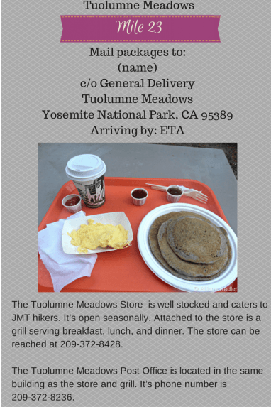 Yosemite Area website (no Tuolumne website available)
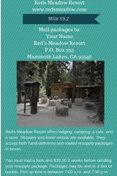
I will be adding additional information to this page including resupply options south of MTR and lodging options in Lone Pine. Am I missing something? Have additional questions? Leave a comment or send me a message at my Trail to Summit facebook page!
Last modified: November 12, 2015


.png)
.png)
This is great. I really enjoyed your trail journal, and this just puts it over the top. The JMT is on my dream list of hikes to do, and reading your trail journal was very inspirational (despite the rain)
Hey Allison, congratulations on a really great, comprehensive guide! And thanks for the shout out in the blog section.
Thanks Tom! That means a lot coming from a fellow JMT thru hiker!
Great site! Thanks for putting all of this together. Do you have any information on how to get back to Yosemite after you get to Lone Pine?
Thanks again!
Hi Matthew. For Yosemite, you can take the ESTA bus to Mammoth, then YARTS to Yosemite. ESTA site: http://www.estransit.com/CMS/ YARTS site: http://www.yarts.com/schedules.html I needed to get to LA for a flight and was able to hitch a ride all the way within minutes. I lucked out!
Hi Allison, I am not sure how to private message you.. But what an awesome review/blog etc.. This is great. I am not a huge hiker but I am trying really hard to get out and the the John Muir Trail this summer (late August).. Am I crazy?? I am from a little city, in Ontario and do a few overnighters etc.. I was just wondering if you had any advice for a newbie.. Cheers
Thanks Kerry! We’re all a little crazy, but I think in order to have a successful hike, make sure you not only get the right gear, but train physically and mentally for hiking all day, everyday. I would definitely join a couple of the facebook groups listed in the guide to get tons of feedback/ideas. I’m not sure if you heard, but permits are tough to get this year in particular for a thru hike. Check out my post here: http://trailtosummit.com/new-permit-system-jmt-thru-hikers/
My biggest piece of advice for the JMT (or any other big hiking goal) is to gather the gear you plan to use and get on the trail for a couple nights. Going solo? Do this test solo. See how comfortable you are camping alone, see what gear works, etc. before you spend weeks or longer on a trail. The other biggest piece of advice is to take into consideration feedback/criticism from others, but with a grain of salt. People can be jerks behind a screen. Haters gonna hate, right? 🙂 Let me know if you have any other questions! Happy trails!
You are doing wrong, that’s why you are making as much money in your investments. For the millionth time these days you have to be able to identify and act to opportunities on the go, you can no longer make money by spending one or two hours analyzing investments. You need to be analyzing and looking at potential investments all they long. Whether you are managing investments for yourself or your clients you have to be on the game everything single minute of the day. For my stock trading investm
Hey Allison -
This is a great post! I wish this would’ve been out there when I was planning my JMT hike. Since doing the JMT, I’ve published a ton of info on my website about it including permits, resupply, gear, campsites, and a full trip report. I would love to be included in the list of blogs that you posted above. My JMT archives can be seen here: http://bearfoottheory.com/category/john-muir-trail/
Thanks and happy trails!
Kristen (Bearfoot Theory)
Hi Kristen,
Love your site! I’ll definitely add it. The more resources the better 🙂 Thanks for reading!
is there any resupply point after Muir Trail ranch. I read that resupply can be done at Onion Valley. Please share your thoughts
Hi Shaki, you can resupply after MTR but it’s not the easiest. I didn’t do it myself but know some who have. Use the Mt Williamson Motel to do this if you choose to. The cost includes breakfast, laundry, and you can send a resupply bucket there. You will have to hike over an additional pass (twice) but Kearsarge pass is easier and quite beautiful (this is what I’ve heard!)
Great information, many thanks for the effort put together on this page.
Can you advise me what my options are. I have a permit in September this year from Tuolumne to Whitney portal and also a permit for Half Dome.
My problem is nothing between Yosemite valley and Tuolumne and transport to Tuolumne is an issue. How do I go about getting a permit via Snow creek trail. I believe this is a good option as no many people take this option due to its steep exit out of the valley. Can I get it now or do I need to walk up on the days preceeding my hike ?
Thanks for any info in advance.
Regards Michael
Australia
JMT is on my bucket list so I’m gathering beta in hopes of one day making it happen. This might just be the best resource I’ve seen so far. Thanks for putting this together!